
Story and photos by Mark Jennings
An unexpected voicemail greeting used to go:
 Insinuating and confiding, a man’s voice starts with a drawn breath and “uh, Uh, UH!, let me tell you About Phil.” There’s a pause. Then comes an abrupt and matter of fact, “He’s not in. Leave a message.”
My version of the closing line would have gone, “He’s paddling the island channels on the New River. Leave a message.” On alternate days it would be, “. . . poling up the Bluestone River,” or “. . . walking out to the bear wallow on Big Draft Wilderness Area,” or mention of lurking around any of my other favorite places.
All of those favorite places here in West Virginia are on public wildlands. There shouldn’t be any surprise in that. Getting permission to enter private land can be hard these days, and more often than formerly, the consequences of even unintentional trespassing can range from nuisance to serious.
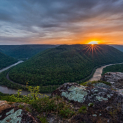
The public woods. Ah. Eight miles of the beautiful, winding Bluestone National Scenic River in Southeast West Virginia are bordered by equally beautiful public forest. The much bigger and nearby New River similarly is protected by tens of thousands of wooded and public acres sprawled along its WV miles. Big Draft Wilderness Area in Greenbrier County is only 5,500 acres. But think of that. Thousands of acres to explore. And all of it is so complexly dissected by hollows and ravines, that you’re not going to soon see and get to know all of its remarkable and secret places.
On public land you can go, and go, and go, and then go some more. And since most of the public woods aren’t managed primarily as a crop to be harvested repeatedly, as is typical on private land, they tend to be older. Because of that their flora and fauna are more diverse and more fun to visit, and the whole tends to look gratifyingly more mature and undisturbed.
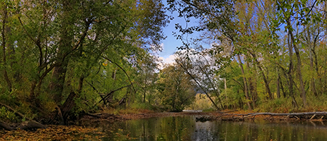
The Last Hole, Looking Toward the Main Channel
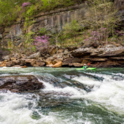
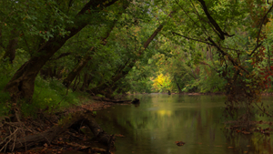
I know a good example, a cloistral place, a small side channel formed by a wooded New River island in the Bluestone Lake Wildlife Management Area. The spot lies 20 miles upstream of the city of Hinton, in Summers County. Along that channel deer come off their afternoon beds and lazily wade across. Two great blue herons claim separate beats. Woodies jump and and go away complaining, “Eeek!, eeek! eeek!” on every other reach. I’ve seen smallmouths on the hunt and channel cats holding in the current over the gravel, sand, and rock bottom.
But my chief animal entertainment has been otters. At times our activities have synced, so as I’ve been taking pictures or scouting, the family of two adults and two pups has been making a weekly tour of this part of its territory. My first view of them was as a group gallumping four abreast across a sand bar, “The Magnificent Four,” I laughed to myself as I thought of a famous scene in a famous old movie. They dove in, “Sploosh, sploosh, kasploosh, kasploosh!”
Four heads popped up and made their way along the deeper water near the far bank, diving as they went. Now and then an emerged head would chew with comic exaggeration and energy. Always they worked up stream and as a group spread out over 15 or 20 yards. I figured they were getting the like of mussels, crayfish, and any small bony fish they could catch.
As months passed I noticed the weekly pattern, but just as importantly I learned how to handle myself. At first even my stationary outline in the canoe got them suspicious inside 50 yards. If the wind was wrong, they’d snort loudly, swim this way and that, and then vanish. But a trick I’d used to stalk a Great Blue Heron came to mind.
When one day I spotted them far off and headed my way, I simply sat down low in the bottom of the canoe. Leaned back against the seat, on the off side I controlled my position in an eddy by one handing a kids’ beach shovel brought along for the purpose.
The canoe had become a big log with a bump on it – my head. To shade my face as much as possible, especially my eyes, I pulled my hat down low. On came the otters. Closer. At 25 yards they didn’t seem to notice. Wow! When directly opposite the two adults hesitated for curious glances my way.
That first success passed too quickly. The channel was unproductive here, so they headed for a deeper, slower section upstream. Struggle with myself I did, but I kept my head from turning when they moved on.
Canoes are handy as blinds. In a kayak the paddler’s outline always is somewhat conspicuous, as is the flailing, flashing double bladed paddle. A canoe, on the other hand, can be moved discretely in any direction without lifting the blade of even a standard paddle from the water.
If you don’t know it’s there, you might not notice the channel entrance. Like the similarly hidden creek mouth described in “The Deerslayer” (Cooper) as the hiding place of the old trapper’s raft, this channel head is protected from the ordinary glance by a screen of low hanging branches and a gloomy interior. The huge wreck of a fallen silver maple blocking the way further confuses the eye.
Sometimes a canoe can slip through a gap in the snag. At other times it’s necessary to get out and drag over a bar and launch just down stream. There the current becomes quick and contrary as it gets forced into a narrow passage. Busy with steering and looking for rocks in the suddenly dimmed light, on one early season descent I narrowly missed head butting a white faced hornet nest attached to a low hanging branch.
The trip down is a leisurely mile on a 25–40-yard wide channel separating the island’s bottom woods from a high, east facing forested scarp. It’s just pretty everywhere. The mostly rock, sand, and gravel channel bottom is usually visible; gentle drops must be dragged over during low water. Through topographic contrast, the long absence of logging and other disturbance, and the local temperature moderating capacity of the river, richly varied native plant and animal populations do OK. These conditions somewhat resist the attacks of climate change and invasive foreign plant species. The place is alive, and there is hope.
Proof that the site advantage and abundance have been noticed for a long time comes just above the mouth. At the foot of a 150-yard reach, the channel bends sharply to the right, toward the main stem, and it divides around a long, narrow and wooded island. The view down the deeply shadowed first fork is irresistible. At the start there’s a little wave train as the boat drops in, then comes a smooth ride down a shadowy tunnel that’s roofed and walled by towering trees. Glimpsed through the darkly framed mouth, the sunshine, glistening water, clouds and mountains of the open river corridor seem far away and dream-like.
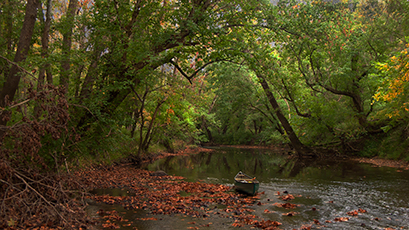
The Going Is Slow, But There’s a Lot to Absorb
The lower fork is different. There the channel becomes a slow hole with gravel beaches on both sides. Tall trees line both shores, but the view of the nearby main channel is open rather than dramatic like the one from the upper fork.The mainland beach and the wooded terraces above it stay in your mind after you’re gone. To start with, here’s first class camping, and it’s as pretty a spot as you’ll see all day. Note: Look but don’t camp: camping is restricted to designated campsites.
Pre-Civil War the area’s river bottom terraces and big islands – including those described here – were farmed with slave labor. An important nearby saltworks and an effort to increase barge traffic on the river also helped make the area settled and busy. Post-Civil War the plantations broke up, however, and the population shrank. The railroad and logging booms of the late 1800s brought people and money once again. But within a decade or two the timber gave out, the saltworks closed, and a thinly populated, insular, primarily subsistence/barter society of small landowners developed. Infamously closed and dangerous during the 20 moonshine years, the backwater reputation was cemented.
Then the WWII migrations that drained all of Appalachia hit particularly hard. The words of an observer in 1948 give a snapshot: “In one particularly remote and almost inaccessible area[just a half mile from the site described on this blog] on the west bank of the New River between Round Bottom Creek and Mercer Saltworks were noted a few cabins of natives . . . These people farm small patches of hillsides and bottom lands there. Their principal mode of transportation was the horse.”
The distant past became better known through a 1948 archeological survey conducted after a federal reserve was created in the 36 miles of the New River valley between the city of Hinton, WV and Narrows, VA to the south. A flood control and hydroelectric dam was being built at Hinton. Today Bluestone Lake stretches 8 miles above the dam. The mostly wooded 18K acres of the U.S. Army Corps of Engineers land surrounding the lake and the river above it is called the Bluestone Lake Wildlife Management Area. It’s run by the WV Division of Natural Resources.
What local people had long known through artifact collecting (pre- reservation) was expanded and described in the survey: on a river terrace above the mainland beach a prehistoric Indian village had stood. The village typically had been home to more or less 200 people and was last occupied in roughly 1500. Two other comparably sized village sites in the reservation were described in the report. [Note: Disturbing and removing artifacts in the reservation are federal offenses.]
Beginning 200 yards above the side channel’s turn toward the main channel, two river bottom terraces open up as the 600’ slope on the channel’s west side pulls back from the water. The two partly wooded terraces perch respectively 30’ and 10’ above the mainland beach. Together they cover about 150 acres. The higher terrace was the site of the village.
Today the upper terrace is a fallow crop field formerly leased by the Army Corps of Engineers, and was last planted in corn. Six hundred years ago the tract might have shown a cluster of mat and bark covered structures surrounded by specialized activity areas and kitchen gardens.
Below the village terrace, about 10’ above the beach and extending north(downstream) of it, lies the other terrace. This one runs along the the main river channel. Today the lower terrace is mostly a collection of fallow and tree lined riverside fields. These are picturesque and haunt the imagination at sunset, when the weight of the centuries is felt. In the very old days they might have supported the village’s large crop fields.
Although 600 years of erosion and deposition undoubtedly have changed the exact form and location of features, it’s probable that in very old times something like today’s gravel beaches and the tranquil pool were part of the community waterfront.
The study noted that the three main prehistoric villages on this part of the New River shared site characteristics. First, all were located on terraces well above flood level. Second, all were protected from the main river stem by large islands and side channels. By these features the villages and their waterfronts were protected from the wind, waves, bank erosion, flooding and general harshness of the big and wide open main river channel.
Finally, all of the sites were adjacent to swamps or sloughs, which have a variety of exploitable plant and animal life. The archeologist pointed out, however, that the islands and swamps might also have been attractive as defenses against detection and approach by hostiles. More recent study points out that, for unknown reasons, at about 1450 a fraction of the New River valley population above Hinton appears to have migrated to related communities in the upper Kanawah River valley.
In any case, a shady and secluded float down a channel behind an island is still there for anyone to enjoy. Imagine a window looking onto peace, beauty, the now undisturbed river bottom’s richness, and the absorbing mystery of the past. It’s public land.
An Archeological Survey of Two River Basins in West Virginia, Ralph S. Solecki, The Bluestone Reservation Survey, WEST VIRGINIA HISTORY, Vol. X, July 1949, Number 4, pp 319-432; New River Symposiums, 1982-1999, CD compiled by the National Park Service.
”Hinton Historical District”, Paul A. Marshall, Proceedings, New River Symposium 1984, National Park Service.